|
|||||


|
|
|
|||
|
|
|
|
|||
|
Français |
|
||||
|
Italiano |
|
||||
|
Español |
|
||||
|
Deutsch |
|
||||
|
|
|
||||
|
|
|
Lodging |
Restaurants |
Directories |
Airport |
|
|
|
Page |
Ste-Agathe |
Mt-Tremblant |
St-Jovite |
|
|
|||||
|
|
|
|
|||
|
|
|
|
|||
|
Français |
|
||||
|
Italiano |
|
||||
|
Español |
|
||||
|
Deutsch |
|
||||
|
|
|
||||
|
|
|
Lodging |
Restaurants |
Directories |
Airport |
|
|
|
Page |
Ste-Agathe |
Mt-Tremblant |
St-Jovite |
|
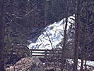
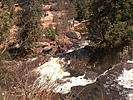
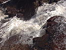
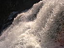
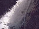
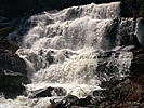
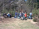
Pictures of the Chute aux Rats Falls in the Mont-Tremblant Park in St-Donat Warning: This page is for information purpose only and cannot be taken as a motive to make the hike. This page is only to share a virtual hiking trail. If you decide to visit the hiking trail, you will have to take the full responsability of any event or accident, as for any typical hiking trail in the woods. The owner of the present site cannot be held responsible for any accident or mishap happening during the course of such activities. Nice hike done by the Club de Plein Air de St-Donat, on May 3rd 2003. I personnally could not participate, but I did go to the Falls by car, and I took these pictures together with the panoramas. The hike is easy and takes less than 2 hours, and if necessary, you can take the road and go by car. Don't forget that there are minimal fees for the entrance of the Park. Take the time to look at the pictures at the bottom of this page and look also at the panorama page at PANORAMA at the bottom of the Falls and PANORAMA near the Falls. Here are the coordinates according to the GPS: At the bottom of the Falls:
|
|||||||||||||||||||||||||||||||||
|
All rights reserved |